





NAMIBIA’s pristine coastline is frequently plagued by bilge dumping from ships. When ships make a ‘bilge dump’ they travel for hours while pumping waste fluids overboard – producing a long, linear oil slick behind them that floats on the water for weeks.
The initial trouble is that marine mammals and birds must surface to breathe and may find themselves in the midst of a bilge dump which covers them with oil.
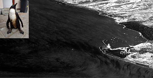
On 5 July 2015 oil-covered penguins coming ashore in Swakopmund indicated yet another bilge dump by a passing ship. The Polytechnic of Namibia was notified to find the oil spill and appeals for aid sent to Airbus and the European Space Agency (ESA) who both tasked urgent image acquisitions by their radar satellites without cost.
The state-of-the-art Sentinel 1A and TerraSAR-X radar satellites provided high resolution and wide coverage of Namibia’s coast and found two oil spills about 20km offshore Swakopmund and another 45 km south-west of Henties Bay. This information was relayed to Namibian authorities for their action. The oil-covered penguins were rescued and treated by Mark Boorman and Sandra Dantu of Swakopmund.
It took four days to process the special requests for data, wait for proper orbital positions then start acquiring the radar imagery. Due to power constraints radar satellites are active less than 15 of their 90 minute orbits, of which about 25 seconds were allocated to each of the 4 images made of the coast between Walvis Bay and Henties Bay. This data was donated but the commercial value is over US$ 12 000. Receiving the satellite imagery in Windhoek was problematic due to slow unreliable internet and many hours were lost to failed download attempts. Oil slicks spread constantly with wind and current and every delay allows further damage to the environment and economy.
The plight of the oil-covered penguins draws attention to a far larger problem. Fishing stocks are declining and by all metrics the vigour of the Benguela Large Marine Ecosystem offshore Namibia is diminishing. The mechanisms remain unclear, but is there a link to oil?
Namibian oyster exports to Hong Kong were banned recently due to cadmium content and the source of this toxin is unknown. However, cadmium is a prevalent heavy metal in the fuel oil being dumped into the ocean. As oil floats on water it degrades into tiny droplets that eventually sink to the seafloor where filter feeders like shellfish ingest the oil. Thus oil and all toxins it carries enter the food chain.
The chemicals accumulate in the sediments which remobilise when disturbed by dredging, mining or fishing nets to drift down-current effecting marine life again long after the oil spills are forgotten. While not yet proven that oil dumping by ships is the vector of contamination to the oysters, it warrants further investigation. A test for certain Polycyclic Aromatic Hydrocarbons (PAH) might support a fuel oil origin of the cadmium.
Namibia is developing its maritime economy via aquaculture and fishing alongside offshore petroleum exploration and expanding the harbour at Walvis Bay, which invites more large vessel traffic and elevates the risk of oil pollution. The skeleton coast is a historically dangerous waterway with hundreds of recorded wrecks. The question is not if an accident will occur here again, but when. And Namibia is critically unprepared to face a major maritime disaster alone. In Radar imagery ships and surface features like oil slicks are easily detected through clouds, fog and darkness which preclude optical satellites or observers in aircraft from reliable maritime domain awareness. So Namibia must develop a radar surveillance programme to monitor and protect its coast including capacity to receive, process and interpret satellite data rapidly.