


A number of villages in the Zambezi region have been submerged by floodwaters, forcing families to leave their homes and seek shelter on higher ground.
The worst affected areas are Namiyundu, Luhonono, Malindi and Lisikili.
Kabbe North constituency councillor Bernard Sisamu says the flooding has intensified over the past three days, with water now passing directly through villages in his constituency.
“We have started relocating the affected residents to the nearest schools and higher grounds.
However, we are challenged by the lack of tents and food items for these relocated families,” he says.
The Zambezi region is currently experiencing devastating floods that have displaced families and livestock, damaged properties, crop fields and roads, and rendered schools and clinics accessible only by boat.
Zambezi River water levels stood at 6.82m as of Friday.
Sisamu says the region urgently needs more tents and food aid, as the assistance provided so far is not enough for the scale of the disaster.
The Office of the Prime Minister (OPM) has provided 60 tents, 50 mattresses, 50 blankets, 104 bottles of cooking oil, 663 tins of fish and 4 974 bags of 40kg rice.
However, Sisamu says none of the relocated families in his constituency have received tents.
“Currently, in my constituency, none of the relocated families have received any tents because the tents provided by the OPM were used for other families in other constituencies.
Therefore, we need more tents as the whole region is affected and resources are limited. The food warehouses are also already empty,” he says.
According to the Namibia 2023 Census, the Kabbe North constituency population stands at 12 253 with 11 958 households.
Last week, regional education director Alex Sikume said nine flood-affected schools in Kabbe South and Kabbe North will soon be relocated for safety reasons.
Currently, these schools are completely surrounded by floodwaters, which have also entered the premises, exposing teachers and pupils to dangers such as snakes, crocodiles, hippos and spiders, as well as the risk of drowning while paddling to school in canoes.
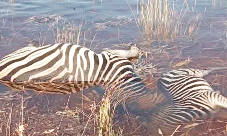
Floods push wildlife into danger
Environment and Tourism has begun mapping wildlife displaced by floods to protect animals from poaching and monitor their locations.
Chief regional control warden Morgan Saisai told The Namibian yesterday that the floods have pushed the wildlife out of their natural habitat, making them vulnerable to poaching.
He added that the mapping will help determine where most of the wildlife are concentrated, with regular patrols serving as a safety measure.
“The floods have made the wildlife soft targets. Some of the wildlife are now placed in the wildlife crime hotspots.
Therefore, the mapping is necessary for us to know where they are and to enforce anti-poaching measures,” he said.
Saisai said the ministry will use boats to navigate deep flood waters to do the mapping.
“The areas that we need to do mapping in are vast.
However, we will do our best to cover all the areas, especially the hotspots,” he said.
The Zambezi region is known as a premier wildlife destination in Namibia, with 450 animal species and 35 large mammal species, including populations of elephants, buffalo, hippos and rare antelope like sitatunga, roan and sable.
Wildlife reside within three national parks – Bwabwata, Mudumu and Nkasa Rupara – and 12 communal conservancies.
In an age of information overload, Sunrise is The Namibian’s morning briefing, delivered at 6h00 from Monday to Friday. It offers a curated rundown of the most important stories from the past 24 hours – occasionally with a light, witty touch. It’s an essential way to stay informed. Subscribe and join our newsletter community.

The Namibian uses AI tools to assist with improved quality, accuracy and efficiency, while maintaining editorial oversight and journalistic integrity.
Stay informed with The Namibian – your source for credible journalism. Get in-depth reporting and opinions for
only N$85 a month. Invest in journalism, invest in democracy –
Subscribe Now!