
Windhoek town planners are too convinced of their solution for the future of the city, which has become very clear during the public meetings.
Apart from that, the entire city service infrastructure is at its limit and aged.
The municipality has run out of money to fix this, let alone expand infrastructure for the current and future increased demand.
By refusing to look into the development of corridors, they have basically shot themselves (and residents) in the foot twice, and another N$5 million will have gone to waste again.
Windhoek will now become the new and improved apartheid city.
We will remain stuck with the informal settlements that are earmarked for romantic ‘upgrading’ exercises, and still no public transport system.
The new spatial development plan for Windhoek has been released and is open for public discussion.
This can be downloaded at: www.Windhoeksdf.com. The overriding idea of the city planners is a citywide densification and intensification, but concentrated exclusively around existing centres, nodes or ‘policy areas’.
Corridors are to be avoided despite it also having been a clear requirement in the Sustainable Urban Transport Master Plan (Stump).
It is being argued that we do not have a public transport system and it will not be an available option in the near or distant future, which makes corridors unviable for now.
Should we go for ‘policy areas’ only and thereby keep the divided and fragmented city as proposed by the municipality, or should we concentrate on nodes and corridors, thereby creating a united, inclusive, sustainable and just new city?
A morphological diagram in town planning is an excellent tool to see and understand instantly what the overall intention or idea of a proposal is.
Depending on the diagram and how it’s being presented, one can quickly guide an argument into a certain direction.
However, it can also very easily misguide through omission or misrepresentation of vital informants and thereby present a deceptive image in support of a chosen argument.
But a picture speaks a thousand words, as the saying goes.
This is the case of the currently proposed Windhoek Structure Plan.
Diagram 1, as presented on pages 52 and 118 of the document, claims that with the thick white line the main centres of Windhoek are connected and form a corridor that supports the ‘towards one city’ slogan, which is printed at the bottom of each page of that document.
However, the so-called secondary centres are in actual fact the current industrial areas which are most certainly not connected with each other as shown or found in reality on the ground.
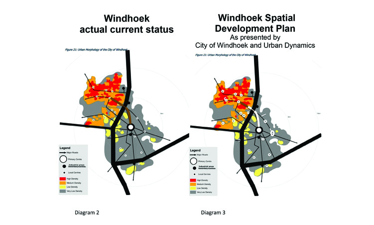
The actual current situation is depicted in diagram 2.
Here it shows clearly that the B1 highway splits the city into two cities, the centres are disconnected and spread all over the place.
The higher and poorer population density is in the north-west, and the richer lower density population is located in the south-east.
Diagram 3 shows the actual proposal of the planners and the city council for the new development of the city – ‘policentricity’ – or maybe WEF’s 15 minute cities?
Apart from the fact that the centre dots are now a little bit bigger because of their focus on densifying the nodes only, I ask, what is the difference between diagram 2 and diagram 3?
It is still the segregated city, the apartheid city, i.e. now the new and improved apartheid city maybe?
Is that all there is for us to expect ‘towards (the) one city’ idea? Is this a strong idea on the way forward or much of the same, still? Does it instil hope and enthusiasm for a brighter future, something to work towards?
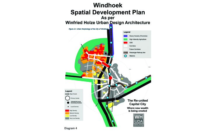
Or should we not rather get excited in bringing the city together again as depicted in my diagram 4 below?
Yes, densification and intensification at nodes is important as well, but it is far more important, effective, economical, sustainable and resilient for it to be along new to be created corridors, i.e. along existing main and arterial roads.
The nodes are then like pearls on a string.
Secondly, there should be the creation of a new Dubai style mega centre with a highly symbolic value, linking east and west between Katutura and the central business district (CBD) over the B1 freeway, called Tulipamwe City Junction maybe.
Thirdly, intensive agriculture along the Hosea Kutako International Airport corridor between the new freeway and the existing railway line only and along the Rehoboth corridor, in line with the new sixth National Development Plans (NDP6) objectives (green employment), should be a priority.
Also, fourthly, the creation of intensive industry along the Okahandja corridor (also in support of the NDP6 objectives – blue employment) should be focused on.
These are all labour-intensive work places that are then linked via a new passenger railway line on or along the existing one with added stations.
And fifthly, the densest and poorest populated area and main workforce is to be linked with that railway line via the new Monte Christo Road (Enias Peter Nanyemba Road) which would then be converted into a high activity and integrative corridor.
Further corridors will follow similar developments as time passes and we managed to convince the planners that corridors are a better option in creating wealth, housing, employment and thereby alleviate poverty, than concentrating exclusively on nodes or ‘policy areas’ only.
Once the corridors get implemented, the people will naturally gravitate towards these, giving up the informal settlement lifestyle, because that is where the action would be.
This then makes a sustainable public transport system viable, subsequently connecting the entire city. In addition, new and future-proofed essential services infrastructure can be installed and financial investments are far more secure.
Through urban design we can together create those fantastic living spaces we all dream of.
The exclusive development of the nodes is only feasible for the elites and big developers and will most certainly remain unaffordable to the masses.
We would remain stuck with the informal settlements that are earmarked for romantic ‘upgrading’ exercises and still no public transport system.
- Winfried Holze is a professional urban designer, architect and marble stone sculptor.
In an age of information overload, Sunrise is The Namibian’s morning briefing, delivered at 6h00 from Monday to Friday. It offers a curated rundown of the most important stories from the past 24 hours – occasionally with a light, witty touch. It’s an essential way to stay informed. Subscribe and join our newsletter community.

The Namibian uses AI tools to assist with improved quality, accuracy and efficiency, while maintaining editorial oversight and journalistic integrity.
Stay informed with The Namibian – your source for credible journalism. Get in-depth reporting and opinions for
only N$85 a month. Invest in journalism, invest in democracy –
Subscribe Now!